Today, the North Dakota State Quarter Coin remembers the date the northern area became a state.
Previously, it had transitioned from one territory to another eight different times.
The ninth transition moved the land area and its inhabitants into the Union as the 39th state.
From The National gazetteer of the United States of America, North Dakota 1990 by the Geological Survey (U.S.), United States Board on Geographic Names, an article by Jon C. Campbell described North Dakota:
=====
North Dakota became a member of the United States on November 2, 1889.
North and South Dakota were admitted to the Union as “Sister States” on the same day, but, on the basis of alphabetical order, North Dakota is the 39th State of the Union and South Dakota is the 40th.
Both States derive their names from the prior political division, Dakota Territory, which was named for the Dakota or Sioux Indians.
Dakota, usually translated as “allies,” is the name that the Sioux people speaking the Santee dialect apply to themselves.
Dakota County, Minn., established in 1849, and the Dakota Land Company, organized in 1857, provided precedents for the use of the word Dakota in a legal name before the Dakota Territory was created in 1861.
The renowned American explorers Lewis and Clark probably made the first written use of a recognizable variant of the name Dakota, spelling it Dacorta, Darcota, and Darcotar in their journals.
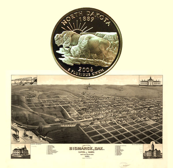
Bismarck, the capital of North Dakota, was named in 1873 by officials of the Northern Pacific Railroad for Otto von Bismarck, Germany’s “Iron Chancellor,” in an effort to attract the attention of German investors.
At that time the site of Bismarck on the Missouri River was the western terminus of the railroad and was generally known as “The Crossing.”
Close by was the town site of Edwinton, surveyed in 1872 and named for Edwin F. Johnson, chief engineer of the Northern Pacific.
The name of the Edwinton post office was officially changed to Bismarck on July 17, 1873.
Although Yankton, now in South Dakota, was the first capital of the Dakota Territory, Bismarck served as the territorial capital from 1883 until statehood in 1889.
A few North Dakota place-names acknowledge the Native Americans who knew the land by other, older names that have not survived.
The Sheyenne River takes its name from the Cheyenne Indians who lived along its banks.
The town of Mandan was commemoratively named in 1878 for the Mandan Indians, once a powerful and numerous people who farmed the valleys of the Heart and upper Missouri Rivers.
The town of Wahpeton was similarly named in 1874 for the local Wahpeton Dakota tribe.
The site of Wahpeton was originally called Richville for the first settler and land holder, Morgan T. Rich, who came to the area in 1864.
In 1873 the name of the post office was changed to Chahinkapa, an Indian phrase that is said to mean “End of the Woods,” but this name was changed to Wahpeton a year later.
A French explorer and fur trader from Canada, Pierre Gaultier de Varennes, Sieur de la Verendrye, was the first white man known to have explored what is now North Dakota.
On the basis of descriptions in la Verendrye’s journal and archeological evidence, most authorities believe that he visited a Mandan village at Menoken, located a few miles east of Bismarck, in December 1738.
Since 1873 this place has been known by several names.
In 1873 the Northern Pacific Railroad built a siding there, known as Seventeenth Siding.
Later the place was called Blaine for James G. Blaine, a U.S. Senator from Maine.
The post office established there in 1880 was named Clarkes Farm for C.J. Clarke on whose farmland the town was later developed.
S.G. Magill bought the Clarke farm and in 1883 platted a town site, which he called Menoken, an Indian name that is said, perhaps fancifully, to mean “Thou shalt reap where thou hast sown.”
La Verendrye’s precedence in the State is remembered in the name of Verendrye, a small community in McHenry County.
French-speaking hunters, trappers, and traders, many of them of mixed blood, figure prominently in North Dakota’s early history and bestowed many geographic names to the State.
The Park River and the Souris River are two examples.
The Park River is reportedly so named because some Assiniboin Indians once made an enclosure, or pen, for buffalo next to the river.
Park, in this case, is an anglicized spelling of the French word parc meaning “pen.”
The Souris River is still often referred to by the English translation of its name, Mouse River.
The name is believed to stem from an incident that occurred before the settlement of the Dakotas when a party that camped on the banks of the river for the winter was nearly routed by hordes of mice.
The first non-Indian settlement in present-day North Dakota was made in 1812 at Pembina under the sponsorship of Thomas Douglas, the Earl of Selkirk, by Scottish, Irish, and Swiss settlers coming from Canada.
The name Pembina, a corruption of the Indian name for the high bush cranberry that is common in the area, was first the name of the river and then was used to refer to the early fur trading post located at the junction of the Pembina and Red Rivers.
Years before the Dakota Territory was organized, this section of the American Northwest was known as “The Pembina Country.”
An 1873 bill introduced before the U.S. Senate suggested Pembina as the name for a proposed northern division of Dakota Territory.
By the terms of the Louisiana Purchase, negotiated in 1803, the United States gained possession of the southwestern half of North Dakota that is part of the Mississippi River basin.
The northeastern part of the State, the area drained by the Red and Souris Rivers, was acquired from Great Britain by the Convention of 1818, which fixed the international boundary at the 49th parallel.
As the Nation expanded westward, the land that eventually would become North Dakota was successively part of Louisiana, Missouri, Michigan, Wisconsin, Iowa, Minnesota, Nebraska, and the Dakota Territories.
=====
The North Dakota State Quarter Coin shows with an 1883 bird’s eye map of Bismarck.