Today, the Nebraska State Quarter Coin remembers when the territory formed on May 30, 1854.
From the Boundaries of the United States and of the several states and territories by Henry Gannett, published in 1900:
=====
The Territory of Nebraska was formed on May 30, 1854, from the northwestern part of Missouri Territory.
Its limits, as originally constituted, are defined as follows in the act of organization:
Beginning at a point in the Missouri River where the fortieth parallel of north latitude crosses the same; thence west on said parallel to the east boundary of the Territory of Utah, on the summit of the Rocky Mountains; thence on said summit northward to the forty-ninth parallel of north latitude; thence east on said parallel to the western boundary of the Territory of Minnesota; thence southward on said boundary to the Missouri River; thence down the main channel of said river to the place of beginning, be, and the same is hereby, created into a temporary government by the name of the Territory of Nebraska. (Thirty-third Congress, first session.)
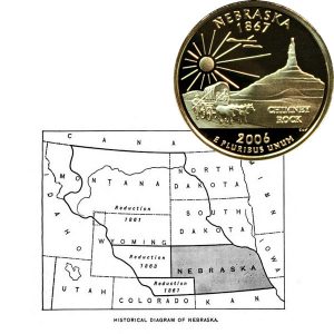
This area was reduced in 1861 by the formation of the Territories of Colorado and Dakota.
The State of Nebraska was admitted on March 1, 1867.
Its limits are defined as follows in the enabling act:
That the said State of Nebraska shall consist of all the territory included within the following boundaries, to wit: Commencing at a point formed by the intersection of the western boundary of the State of Missouri with the fortieth degree of north latitude; extending thence due west along said fortieth degree of north latitude to a point formed by its intersection with the twenty-fifth degree of longitude west from Washington; thence north along said twenty -fifth degree of longitude to a point formed by its intersection with the forty-first degree of north latitude; thence west along said forty-first degree of north latitude to a point formed by its intersection with the twenty-seventh degree of longitude west from Washington; thence north along said twenty-seventh degree of west longitude to a point formed by its intersection with the forty-third degree of north latitude; thence east along said forty-third degree of north latitude to the Keyapaha River; thence down the middle of the channel of said river, with its meanderings, to its junction with the Niobrara River; thence down the middle of the channel of said Niobrara River, and following the meanderings thereof, to its junction with the Missouri River; thence down the middle of the channel of said Missouri River, and following the meanderings thereof, to the place of beginning. (Thirty-eighth Congress, first session.)
In 1870 an act was passed to redefine a portion of the boundary between Nebraska and the Territory of Dakota, the pertinent portion of which is as follows:
That so soon as the State of Nebraska, through her legislature, has given her consent thereto, the center of the main channel of the Missouri River shall be the boundary line between the State of Nebraska and Territory of Dakota, between the following points, to wit: Commencing at a point in the center of said main channel, north of the west line of section twenty-four in township twenty-nine north, of range eight east of the sixth principal meridian, and running along the same to a point west of the most northerly portion of fractional section seventeen, of township twenty-nine north, of range nine east of said meridian, in the State of Nebraska, as meandered and shown by the plats and surveys of said sections originally made and now on file in the General Land Office. (Forty-first Congress, second session.)
The west boundary on the twenty-fifth degree of longitude west of Washington, between latitudes 40° and 41°, the south boundary on the forty-first parallel from the twenty-fifth degree of longitude to the twenty-seventh degree, and the west boundary on the twenty- seventh degree of longitude, between the forty-first degree and the forty-third degree, were surveyed and marked in 1869, under the General Land Office.
In 1882 an act was passed transferring to this State from Dakota a small area lying between the Keyapaha River and the forty-third parallel of latitude.
The following is the act in question:
Be it enacted, * * * That the northern boundary of the State of Nebraska shall be, and hereby is, subject to the provisions hereinafter contained, extended so as to include all that portion of the Territory of Dakota lying south of the forty-third parallel of north latitude and east of the Keyapaha River and west of the main channel of the Missouri River. (Forty-seventh Congress, first session.)
The north boundary, from the Keyapaha River westward, was surveyed in 1873.
In 1893 the part of this boundary east of Keyapaha Eiver was surveyed and the remainder resurveyed. All this was done under the General Land Office.
=====
The Nebraska State Quarter Coin shows with an historical map showing the territory then the reductions to the state boundary.