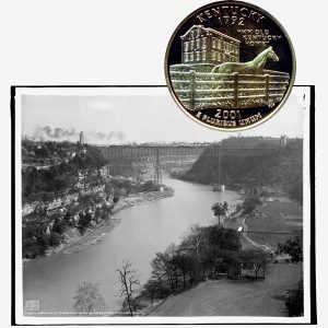
Today, the Kentucky State Quarter Coin remembers the first charter for a company to clear the rivers on December 19, 1801.
From the Collins’ Historical Sketches of Kentucky, History of Kentucky by Lewis Collins, revised with additional information by his son, Richard H. Collins, published in 1882:
=====
The first act passed by the Kentucky legislature in reference to water courses was that of Dec. 15, 1792, making a penalty of $2 for each 24 hours any obstruction was continued to the passage of fish or boats in any navigable stream—except said obstruction were a dam for the purpose of working a water grist-mill or other water-works of public utility, in conformity with the old law of Virginia.
By the second act, that of Dec. 19, 1793, commissioners were appointed to raise—by subscriptions of money, labor, or property—a fund for clearing and opening the navigation of the South fork of Licking, from its mouth (at Falmouth) to the junction of Hinkston, and Stoner, and also that of Stoner’s fork, as high as the mouth of Strode’s creek.
On the latter stream, the mills or mill-dams then erected should not be removed or pulled down; but the owners thereof should, by Dec., 1801, build sufficient locks and slopes for the passage of all boats that ma navigate the said forks.
By two subsequent amended acts, the latest being Dec. 18, 1798, the first lottery in aid of river navigation was authorized.
By act of Dec. 12, 1794, the mills and fish-dams and other obstructions in main Licking river and Slate creek were ordered to be effectually removed b May 1, 1795—under £30 penalty.
But this policy was reversed, Dec.21, 1799, by an acts permitting mill-dams across Main Licking, provided that below the mouth of Slate creek dams should not exceed two feet in height, and should have such locks and slopes as would secure the free passage of boats and fish.
Another act, of same date, permitted dams not over seven feet high, for water grist-mills, on the South fork of Licking, but with like slopes and locks sufficient for the passage of fish and boats.
Under the first of these, Maj. Geo. M. Bedinger built a dam, with lock and slope on Main Licking, near (just above) the lower Blue Licks.
But such were the evasions or violations of the law, as to an efficient slope in the dams on South Licking and Stoner, that an amended act of Dec. 16, 1802, required the slope (having reference to the bed of the stream, both above and below the dam) to be of the following dimensions:
“The level of the upper end of the slope shall he at least two feet lower than the rest of the dam, on each side thereof; and the ends of the timbers of the dam, on each side of the slope, shall be beveled or sloped, so as to prevent boats from hanging upon the corners or ends of the dam.
“The slope shall be at least 40 feet wide; and the apron or slant of the slope below the dam shall be extended 8 feet in length, for every foot the dam shall or may be raised in perpendicular height (measuring to the level of the upper end of the slope).
“The apron or slant of the slope shall be made of strong timbers, closely joined together, to prevent the water from running through; and on each side of said apron or slant, shall be fixed a strong piece of timber, 15 feet, adjoining to the dam—raised 2 feet above the apron of the slope, to prevent the water from flying off at the sides.
“There shall be a sign or index suspended over the center of the slope, for a guide for boatmen. . . . .
“Each mill owner shall keep his slope constantly in good repair, shall clear away all drift-wood lodged against or about the slope, and also cut down all trees standing in the bed or channel of the river, and such leaning trees as might injure the passage of boats, and also burn or remove all drift-wood for the distance of at least 200 yards below the mill-darn.”
A penalty was fixed, of $10 for each 24 hours of failure to comply, to the person suing for the same.
But all these acts proving inadequate to remove and prevent the obstructions in the navigation of the South and Stoner’s forks of Licking, the act of Dec. 15, 1804, appointed commissioners in both Bourbon and Harrison counties to examine and estimate the cost of removing the natural obstructions, to open subscriptions for a fund to pay same, and to contract for said work to be done; if necessary, $500 additional to the fund subscribed should be raised as part of the county levy.
The first company chartered to improve the navigation of any river in the state was “The Kentucky River Company,” on Dec. 19,1801, with $10,000 capital stock, shares $50 each—to be subscribed in the counties and under direction of commissioners as follows:
Franklin—Christopher Greenup, Bennett Pemberton, Thos. Todd — 20 shares.
Woodford—Robert Alexander, Thos. Bullock, Wm. Steele — 20 shares.
Fayette—Jas. Trotter, John Jordan, Thos. Wallace — 30 shares.
Clark—David Bullock, Robert Clark, Jr., Dillard Collins — 15 shares.
Madison—John Patrick, Jas. Barnett, John Wilkinson — 22 shares.
Garrard—John Harrison, Thos. Kennedy, Abner Baker — 18 shares.
Mercer—Gabriel Slaughter, Jas. Birney, Jas. Moore — 22 shares.
Jessamine—Wm. Price, Geo. Walker, Benj. Bradshaw — 15 shares.
Scott—Wm. Henry, David Flournoy, Bartlett Collins — 20 shares.
Lincoln—Isaac Shelby, Wm. Logan, Wm. Whitley — 18 shares.
Said company was to clear out of the Kentucky river, from its mouth to the mouth of its South fork, all obstructions which “they may judge will impede or obstruct the passage of boats, or which shall be absolutely necessary to improve the navigation of the river.”
When so completed, and so long as approved by two commissioners appointed by the governor to examine the navigation annually, in July or August, it was made lawful for the company to collect tolls as follows:
For each boat not more than 14 feet wide and 30 feet long, $4; 45 feet, $5; 60 feet, $6; and 9 cents for each foot larger.
For each keel-boat, periogue, or canoe, of over 1 ton burden, 12.5 cents for each foot in length.
For each 100 hogshead or pipe staves or headings, or each 100 feet of plank or scantling, if floated on a raft, 4 cents, or of other timber, 12.5 cents.
Boats loaded with coal, lime, iron, or other ore, or household furniture, to pay not over three-fourths of the above rates.
The undertaking seemed too great for even such a substantial body of men; and after nine years of continued losses from obstructions, another favorite paper-plan was set on foot, by act of Jan. 10, 1811.
This authorized the raising of $10,000 by lottery, under the care of eleven other leading men—to be expended in “clearing of all logs, brush, trees, rocks, fish-traps, shrubbing the points of islands, and removing other impediments ” from the Kentucky river, and its South fork, and Goose creek, as high up as the salt works of Gov. James Garrard and Sons.
“Further time was allowed,” several times, but nothing practical done, as late as 1813.
=====
The Kentucky State Quarter Coin shows with an image of the Kentucky River, circa 1907.